
The 2D3D Floor Plan Company provides professional 2D and 3D site plan rendering services for property developers, architects, urban planners, real estate agents, and land marketing teams across the United States and worldwide. We produce accurate, presentation-ready site plan visualizations – from clean 2D layout drawings to fully rendered aerial 3D site plans – delivered in 2 to 5 business days at a fixed, transparent price with unlimited revisions.
Whether you need a 2D site plan for a planning submission, a colored 3D aerial site plan for a development brochure, or a photorealistic bird’s-eye rendering for an investor presentation, our experienced design team produces results that communicate your project with the clarity and authority it deserves.
| ✓ Trusted by 1,250+ Clients | ✓ From $99 Per Plan | ✓ Delivery in 2–5 Business Days | ✓ Unlimited Revisions |
Submit Your Project → | View Pricing → | Get a Custom Quote →
What is a Site Plan?
A site plan is a scaled drawing or rendering that shows a property from directly above – depicting the land, the building footprint, and the surrounding site context: driveways, parking, landscaping, boundaries, access points, neighbouring roads, and orientation. Unlike a floor plan, which shows the interior layout of a building, a site plan shows the relationship between the building and its land – and between the site and the wider environment around it.
Site plans serve two distinct purposes depending on their format. A 2D site plan is a technical drawing used in planning applications, construction documentation, and regulatory submissions – precise, measured, and professionally annotated. A 3D site plan rendering is a photorealistic aerial visualization used in development marketing, investor presentations, and sales materials – visually rich, immediately engaging, and designed to communicate the project’s scale, character, and setting to a non-technical audience.
We produce both. For many development projects, clients order a 2D site plan for planning and a 3D rendering for marketing – two different outputs, both produced from the same input files.
Also known as: site plan drawing, aerial site plan, bird’s-eye site plan, 3D aerial rendering, site layout plan, development site plan, plot plan, location plan, master plan visualization, 3D site visualization.
| Site Plan vs. Floor Plan – What’s the Difference? A floor plan shows the interior layout of a building from above – room positions, walls, doors, dimensions, and spatial flow. A site plan shows the building from above as part of its land – the footprint, plot boundaries, parking, landscaping, access, and surrounding context. Many development projects require both: a site plan for planning submissions and exterior context, and floor plans for the individual unit layouts. See our full range of floor plan services → For a detailed comparison, see our guide: Site Plan vs. Floor Plan – Fundamentally Different. |
Types of Site Plan Renderings We Offer
We produce site plans at three levels of visual detail, each suited to a different purpose, audience, and budget.
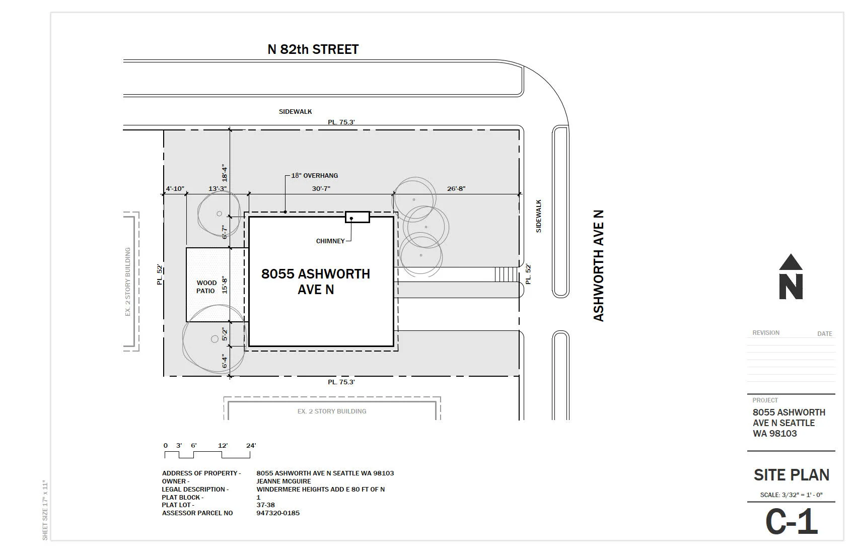
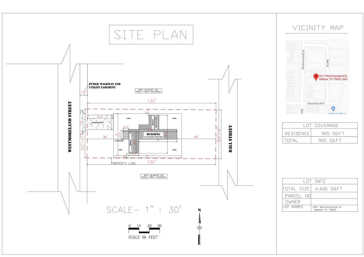
1. 2D Site Plan Drawing
A 2D site plan is a clean, precise, top-down technical drawing showing the building footprint, plot boundaries, access points, parking areas, landscaping zones, and key site features – accurately scaled and annotated. This is the standard format for planning applications, local authority submissions, construction documentation, and regulatory compliance. It is produced in monochrome or with basic color fills for zone differentiation.
What a 2D Site Plan Drawing Includes:
- Building footprint – accurately positioned on the plot with correct setbacks and orientation
- Plot boundaries and dimensions – legal boundary lines, easements, and overall site dimensions
- Access and circulation – driveways, pathways, pedestrian routes, and vehicle entry/exit points
- Parking and hardstanding – car park layouts, disabled bays, loading areas
- Landscaping zones – planted areas, lawn, trees, hedging, and boundary treatments indicated
- North orientation arrow and scale bar
- Annotations and labels – room uses, zone labels, dimensions, and any required planning notes
- Neighbouring roads and streetscape – road names, kerb lines, and adjacent plot boundaries where required
Ideal For: Planning applications and local authority submissions, construction site packages, building permit documentation, land sale marketing, and any use case requiring a measured technical site drawing.
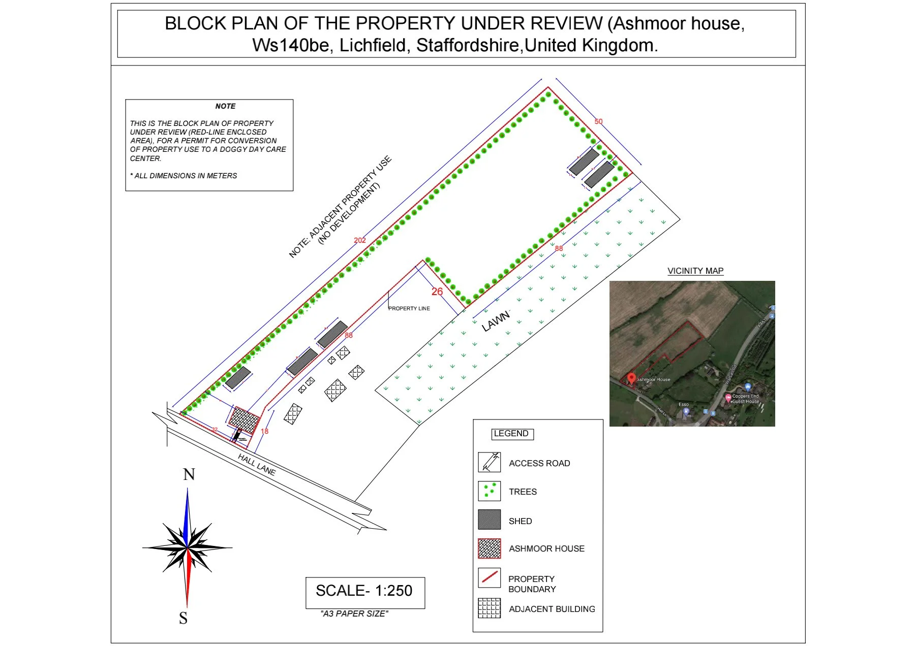
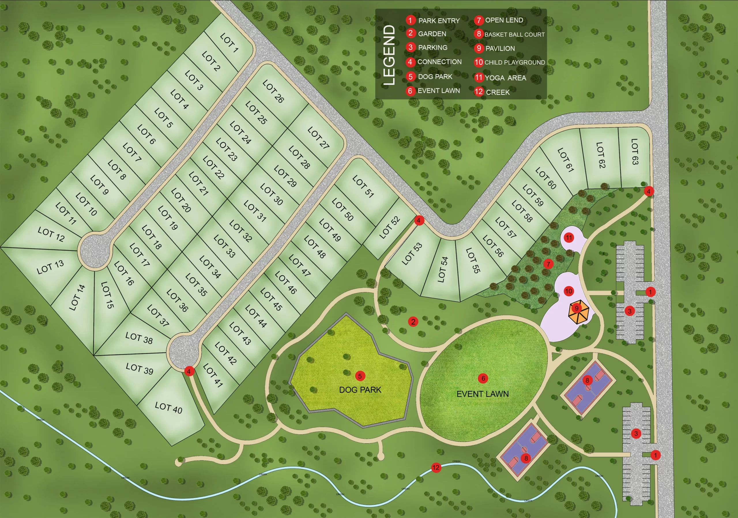
2. Coloured 2D Site Plan
A coloured 2D site plan takes the same accurate technical drawing and applies colour fills, material textures, and professional styling to make the plan immediately more engaging and legible for non-technical audiences. Building footprints, parking areas, landscaping zones, roads, and water features are differentiated with distinct colours, and the overall plan is styled to a presentation standard suitable for brochures, websites, and planning reports.
What a Coloured 2D Site Plan Includes:
- All elements of the 2D site plan drawing
- Color-coded zones – buildings, parking, landscaping, roads, and amenities clearly distinguished
- Texture fills – grass, gravel, tarmac, paving, water, and planting zones indicated visually
- Shadow and depth – subtle building shadows and layered fills that give the plan visual clarity
- Custom color palette – matched to your brand, development identity, or planning authority style guide
- Legend and labelling – land use key, area calculations, and any required development notes
Ideal For: Development marketing brochures, planning reports, investor presentations, sales office displays, and leasing materials for commercial sites.
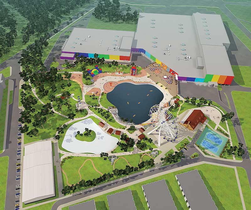
3. 3D Aerial Site Plan Rendering
A 3D aerial site plan rendering is a photorealistic, bird’s-eye visualization of your site — showing the buildings, landscaping, roads, parking, and surrounding context in full three-dimensional detail. Buildings have accurate height and massing, trees and planting are rendered in three dimensions, and the entire composition is lit with natural daylight. The result is the most compelling visual tool in development marketing: immediately legible, visually impressive, and communicating the project’s scale and character in a single image.
What a 3D Aerial Site Plan Rendering Includes:
- Full 3D building massing – accurate height, roof form, materials, and facade treatment for all buildings on site
- Photorealistic landscaping – mature trees, grass, planting beds, hedgerows, and water features rendered in 3D
- Roads, paths, and parking – accurate surface materials, kerbing, bay markings, and circulation routes
- Surrounding context – neighbouring buildings, roads, fields, or urban streetscape shown at the appropriate level of detail
- Natural daylight lighting – sun angle, shadows, and ambient light composed for maximum visual impact
- Entourage – vehicles, pedestrian figures, and landscape elements that give the scene scale and life
- High-resolution output – delivered at up to 4K resolution, suitable for large-format printing and digital use
Ideal For: Development marketing, pre-sales campaigns, investor presentations, planning authority submissions where visualisation is required, sales office displays, and project websites for residential, commercial, and mixed-use developments.
| Not Sure Which Format You Need? Most development projects use a 2D site plan for planning and a 3D aerial rendering for marketing. Many clients order both from the same set of input files – we build the geometry once and deliver both outputs. If you are unsure, contact us with your project brief and we will recommend the right combination for your use case and budget. |
What You Need to Send Us
We work with input materials in any format. You do not need a complete CAD package or survey drawings to get started.
| Input Type | What to Send |
| Site Survey / OS Map | An Ordnance Survey extract, surveyor’s drawing, or any official site survey showing plot boundaries and context. PDF, DWG, or image format. |
| CAD Files (.dwg / .dxf) | AutoCAD or compatible files for the highest dimensional accuracy. The preferred input for complex or large-scale developments. |
| Architectural Site Layout | Any architectural site layout drawing – as-designed or as-built. PDF, JPG, or PNG accepted. |
| Planning Documents | Planning permission drawings, design and access statements, or any approved site layout from a planning authority. |
| Floor Plans or Building Drawings | Floor plans help us determine building footprint and massing where a full site drawing is not available. |
| Aerial / Satellite Imagery | Google Maps, Google Earth, or any aerial photo of the site showing current context and plot shape. |
| Hand-Drawn Sketch | A rough sketch with approximate site dimensions and building positions photographed on your phone. Rough is fine – we work from it. |
| Reference Imagery | Photos of the site, comparable developments, or any visual reference showing the style, landscaping, or character you want. |
Along with your files, let us know:
- 2D, colored 2D, or 3D aerial rendering – or a combination
- North orientation – if you have a preference for which direction the plan faces in the final image
- Building heights and materials – for 3D renderings; approximate heights are sufficient if exact figures are unavailable
- Landscaping style – formal, naturalistic, contemporary, or matched to your development character
- Season preference – for 3D renders, summer (full canopy) or winter (bare trees) changes the character significantly
- What the plan is for – planning, marketing, investor presentation, sales office display – we make appropriate professional choices based on the end use
Who Uses Our Site Plan Rendering Service
Property Developers
A photorealistic 3D aerial site plan is the hero image of any development marketing campaign. It shows the entire scheme at a glance – building positions, landscaping, roads, parking, and surrounding context — communicating the scale and character of the development to buyers, investors, and planning authorities in a single image. We produce site plan renderings for residential developments of all sizes, from penthouse and apartment developments to large mixed-use schemes, used in sales offices, development websites, planning applications, and investor decks.
Architects and Urban Designers
Present your site design with the visual clarity that 2D drawings alone cannot achieve. Our 3D aerial renderings are produced directly from your CAD files or design drawings – showing the massing, landscaping, and site context with the photorealistic quality required for planning authority submissions, heritage assessments, and design panel reviews. For architectural projects that also require exterior building renders, our 3D exterior rendering service can be produced alongside the site plan from the same input files.
Real Estate Agents and Land Brokers
For land sales, large-plot properties, and multi-unit developments, a site plan is the marketing asset that communicates what photographs cannot: scale, layout, and spatial context. A colored 2D site plan or a 3D aerial rendering gives buyers and investors the overview they need to understand a site’s potential before a physical visit. Delivered in 2 to 5 business days, formatted for immediate use in listings and marketing materials. For a detailed look at how site plans work alongside property floor plans, see our guide: Site Plan vs. Floor Plan — Fundamentally Different.
Planning Consultants and Heritage Applicants
Planning authorities increasingly expect high-quality site visualisation as part of development applications — particularly for residential schemes in sensitive locations, green belt land, heritage settings, and areas with established character. A 3D aerial site plan rendering demonstrates proposed massing, landscaping, and relationship to neighbouring properties with a precision and visual clarity that 2D site layouts cannot match. We produce site plan renderings for planning submissions with the accuracy and contextual grounding that applications require.
Hotel, Hospitality, and Resort Developers
Resort developments, hotel campuses, and hospitality projects often span complex multi-building sites with intricate landscaping, access, and amenity arrangements. A 3D aerial site plan communicates the full guest experience — building layout, pool and amenity positions, parking, access, and landscaping character — in a single, compelling image. See our blog for an overview of how hotel floor plans and site plans work together in hospitality development marketing.
Agencies and White-Label Partners
Architecture firms, planning consultancies, real estate marketing agencies, and photography studios regularly outsource their site plan production to us. We operate as a white-label production partner – delivering finished site plan renderings under your brand, on your timeline, at wholesale pricing. Our name does not appear anywhere in the deliverable. Contact us to discuss volume arrangements.
Development Types We Cover
We produce site plan renderings for all development scales and categories:
| Residential Developments | Commercial & Mixed-Use |
| Single-plot residential developments | Mixed-use commercial and residential schemes |
| Housing estates and subdivisions | Office parks and business campuses |
| Apartment and condominium complexes | Retail centres and shopping developments |
| Townhouse clusters and row housing | Industrial estates and logistics parks |
| Penthouse and luxury developments | Hotels, resorts, and hospitality campuses |
| Senior living and retirement communities | Healthcare facilities and hospital campuses |
| Student housing and PBSA developments | Educational campuses and schools |
| Rural and agricultural land plots | Leisure and recreation developments |
How the Process Works
Four steps. Minimal effort on your side.
Step 1: Place Your Order
Order directly using our fixed pricing, or request a custom quote for large-scale developments, multi-building schemes, or projects with complex site requirements. Your order confirms the scope and timeline before we start.
Step 2: Submit Your Files and Brief
Send us your site survey, CAD files, architectural drawings, aerial images, or planning documents in any format. Include your preferences for output type (2D, coloured 2D, or 3D aerial), orientation, building heights, landscaping style, and season. If you are unsure about any of these, tell us what the plan is for and we will advise.
Step 3: We Model, Compose, and Render
Our team builds an accurate site model from your input, places buildings at correct height and massing, composes the landscaping and context, and renders the final image. For 3D aerial renderings, we apply natural daylight lighting and entourage to produce a photorealistic result. First draft delivered within 2 to 5 business days, confirmed at order.
Step 4: Review, Revise, Approve
Review the draft and tell us what to adjust — building positions, landscaping, labelling, colour, camera angle, level of surrounding context, or any other element. We revise at no additional cost, with no limit on revision rounds. Once approved, we deliver your final high-resolution files immediately.
Site Plan Rendering Pricing
Our pricing starts from $99 for a 2D site plan and $249 for a 3D aerial site plan rendering. Pricing is fixed and transparent — published in full on our pricing page. No hidden fees, no hourly rates, no surprise charges after delivery. For large-scale or complex multi-building developments, contact us for a custom quote.
| Service | Starting Price |
| 2D Site Plan Drawing | From $99 per plan |
| Coloured 2D Site Plan | From $149 per plan |
| 3D Aerial Site Plan Rendering | From $249 per plan |
| 2D + 3D combination (same input) | Custom quote — contact us |
| Large-scale / multi-building development | Custom quote based on site complexity |
| Rush delivery (48-hour first draft) | Additional charge applies |
| Bulk / volume pricing | Contact us for a custom rate |
| 2D and 3D Together Costs Less: If you need both a 2D site plan for planning and a 3D aerial rendering for marketing, ordering both together saves significant cost — the site geometry is built once and used for both outputs. Contact us or see our pricing page for combination package options. |
View Full Pricing Breakdown →Get a Custom Quote →
Site Plan Rendering Samples
Before ordering, see the quality and range of our work across 2D, coloured 2D, and 3D aerial site plan formats.
2d Site Plan Rendering Samples
2d Colored Site Plan Rendering Samples
3d Site Plan Rendering Samples
View All Site Plan Rendering Samples →
Technical Specifications
| Output Formats | JPEG and PNG standard; transparent PNG background and PDF available on request |
| Resolution | Up to 4K (3840 × 2160px); web-optimised versions included at no extra cost |
| Dimensional Accuracy | 99%+ accuracy from CAD or surveyed drawings; we flag any gaps or inconsistencies before starting |
| Turnaround Time | 2–5 business days for most residential site plans; large-scale commercial or multi-building sites may take longer |
| Rush Delivery | 48-hour first draft available for standard site plan orders (additional charge applies) |
| Accepted Input Formats | CAD (.dwg, .dxf), PDF, JPG/PNG site drawings, OS maps, aerial/satellite imagery, hand sketches |
| Orientation Options | Any compass orientation — we compose the view based on your brief and marketing objectives |
| Season Options | Summer (full canopy), spring (light canopy), or winter (bare trees) — specify at order |
| Lighting | Daytime natural light; sun angle and shadow direction adjustable on request |
| Entourage (3D) | Vehicles, pedestrian figures, mature trees, and neighbouring context included as appropriate |
| Labelling | Building labels, zone annotations, dimensions, north arrow, scale bar — included or omitted as required |
| Revisions | Unlimited revisions until approval — no caps, no extra charges |
| Pricing | From $99 (2D) / $249 (3D aerial) — volume discounts available |
Why Clients Choose The 2D3D Floor Plan Company
One quality level – and it’s our best. Whether you order a 2D site plan or a fully rendered 3D aerial, every deliverable is produced by an experienced designer who builds your site from your actual drawings, models accurate building massing, and composes a result that represents your project with professional credibility. We do not use stock site templates or reused assets.
Accessible pricing, not accessible quality. Our design team operates with significantly lower overhead than UK, US, or Australian visualization studios. We pass those savings directly to our clients. From $249 for a 3D aerial site plan rendering is not a budget product – it is studio-quality visualization at a price that makes professional site plans accessible for projects of every scale.
Any input, any site complexity. We have built site models from hand-drawn sketches, from a Google Maps screenshot with handwritten dimensions, and from incomplete planning drawings. We work with whatever you have. If your input is missing something we need – a boundary dimension, a building height – we will flag it before proceeding.
Fixed price. No revision charges. No surprises. Every project is quoted before we start. We do not charge by the hour, add fees for revision rounds, or adjust the invoice after delivery. If something is not right, we fix it – as many times as needed.
Trusted by 1,250+ real estate and development professionals. Our clients range from sole-trader architects to national property developers and international hospitality groups, across the US, UK, Canada, and Australia. We have delivered over 1,250 projects with a consistent standard of accuracy and visual quality.
Fast turnaround, every time. 2 to 5 business days for most site plans. Rush delivery available. We work across time zones and accommodate planning deadlines, investor meeting schedules, and launch-day marketing timelines.
Site Plan Rendering by Use Case
Planning Applications and Development Submissions
Planning authorities require accurate site plan drawings as part of virtually every development application — and for significant schemes in sensitive locations, they increasingly expect photorealistic site visualizations that demonstrate proposed massing, landscaping, and integration with the surrounding environment. A high-quality 3D aerial site plan rendering shows how your development sits within its context with a visual authority that a 2D drawing cannot deliver alone. We produce site plan renderings for planning submissions with accurate building dimensions, correct site boundaries, and appropriate surrounding context — produced to the standard that planning officers and committees expect.
Pre-Sales and Development Marketing
The 3D aerial site plan is the opening image of almost every development marketing campaign. It communicates the full scheme – where the buildings are, how they relate to each other, what the landscaping looks like, how the site connects to the surrounding area – in a single, immediately compelling image. Buyers and investors understand the development before they read a word of copy. We produce 3D aerial site plan renderings for sales center displays, development websites, investor decks, printed brochures, and social media campaigns. For a complete pre-sales visual package, our site plan renderings are commonly produced alongside 3D exterior renderings, 3D floor plans, and 3D interior renderings – giving buyers the exterior, layout, and interior picture together.
Land Sales and Plot Marketing
Selling land or large-plot properties is a visual challenge. A site plan rendering communicates scale and potential – showing buyers not just the dimensions of a plot, but what could be built on it. Whether you are marketing agricultural land with planning permission, a brownfield site with outline consent, or a subdivided residential plot, a 3D aerial site plan or a colored 2D drawing gives your land listing the visual credibility it needs to attract serious buyers. For an overview of how site plans work in the broader context of property documentation, see our guide: Site Plan vs. Floor Plan — Fundamentally Different.
Investor Presentations and Funding Packages
Investors reviewing a development opportunity need to understand the site – its scale, layout, relationship to infrastructure, and visual character – quickly and confidently. A photorealistic 3D aerial site plan delivers that understanding in seconds. It communicates professionalism, preparedness, and the credibility of the scheme in a way that technical drawings and text descriptions cannot. Our site plan renderings are regularly used in funding applications, equity raise decks, and JV presentations where first impressions are tied directly to investor confidence.
Master Planning and Large-Scale Developments
For large residential estates, mixed-use schemes, business parks, and campus developments, a 3D aerial site plan is both a planning tool and a marketing asset. It shows the full scheme – multiple building types, roads, parking, amenity spaces, open land, and context – at the scale and level of detail required for master plan presentations. We produce site plan renderings for phased developments showing individual phases and overall masterplan extent, for affordable housing schemes requiring planning committee approval, and for large-scale hospitality and resort developments. For developments requiring aerial perspective pricing context, see our guide on 3D aerial rendering cost.
Related Services
We offer a complete range of floor plan and rendering services. Site plan clients frequently combine their order with:
| Service | What It Covers |
| 3D Exterior Rendering Services | Photorealistic building facade renders – show the exterior character of the buildings on your site |
| 3D Floor Plan Services | Interior layout renderings for individual units – pair with site plans for a complete development marketing package |
| 3D Interior Rendering Services | Room-level photorealistic visualizations – show buyers what the inside of your development looks like |
| 2D Floor Plan Services | Precise 2D layout drawings for individual units – for planning submissions and construction documentation |
| 2D to 3D Floor Plan Conversion | Convert existing 2D unit floor plans to photorealistic 3D renderings |
Frequently Asked Questions
What is the difference between a 2D site plan and a 3D aerial site plan rendering?
A 2D site plan is a flat, technical drawing viewed from directly above – scaled, annotated, and produced for planning submissions, regulatory documentation, and construction use. A 3D aerial site plan rendering is a photorealistic bird’s-eye visualization showing the same site in three dimensions – with building height and massing, landscaping, roads, and surrounding context rendered in photorealistic detail. 2D plans are required documents; 3D renderings are marketing and presentation assets. For most development projects, both serve a purpose – the 2D for planning and the 3D for marketing.
What files do I need to provide?
The most useful input is a site layout drawing – in any format (PDF, JPG, PNG, or CAD .dwg/.dxf). We also work from OS map extracts, Google Maps screenshots with dimensions noted, architectural site plans, planning documents, and hand-drawn sketches. For 3D renderings, approximate building heights and a brief description of the desired landscaping style are helpful but not essential — if you do not have this information, we will make appropriate professional choices and you can refine them at the revision stage.
How long does a site plan rendering take?
Most standard residential site plan renderings are delivered within 2 to 5 business days of receiving your files and brief. The exact timeline depends on site size, number of buildings, level of surrounding context required, and whether you have ordered 2D, 3D, or both. Large-scale commercial or master plan projects may take longer – your exact timeline is confirmed when you place your order. Rush delivery is available for most orders at an additional charge.
Can I order both a 2D site plan and a 3D rendering from the same input?
Yes – and it is almost always more cost-effective to order both together. The site geometry is built once from your input files, and both the 2D drawing and the 3D aerial rendering are produced from the same model. Ordering separately at different times means rebuilding the model from scratch. Contact us for a combined package quote.
What level of surrounding context do you include in the 3D rendering?
We include the level of surrounding context that is appropriate for your site and its use. For planning submissions, we typically show adjacent roads, neighbouring building masses, and immediate streetscape. For development marketing, we compose the scene to present the site at its best – with appropriate landscaping, sky, and context. We will discuss context level with you when you submit your brief, or make appropriate choices based on the end use if you prefer to leave it to us.
Can you show different landscaping or massing options?
Yes. Once the 3D model is built, rendering it with different landscaping treatments, tree positions, building colours, or massing options is straightforward and cost-effective compared to re-doing the full model. Many planning applicants use this to compare design options, and developers use it to show phasing. Contact us for a quote on multiple variants.
How many revisions are included?
Every order includes unlimited revisions at no additional cost. If the first draft needs adjustments to building positions, landscaping, labelling, camera angle, colour palette, or any other element, you provide feedback and we revise it – as many times as needed. We do not cap revision rounds or charge extra for changes.
What resolution are the final files?
We deliver at up to 4K resolution (3840 × 2160px) as standard – suitable for web use, digital presentations, print brochures, and large-format display. Web-optimised versions are included. For specific large-format print requirements such as site hoardings, exhibition displays, or A0 planning boards, let us know your output dimensions and we will confirm the render resolution required.
Can I use the site plan rendering in a planning submission?
Yes. Our 3D aerial site plan renderings and 2D site plan drawings are regularly used in planning applications and local authority submissions. For planning use, let us know when you order so we can ensure accurate boundary representation, correct annotation, and the appropriate level of contextual detail for the authority’s requirements. We produce renderings to the visual standard that planning officers and design review panels expect.
Do you offer white-label arrangements for agencies and studios?
Yes. We work with architecture firms, planning consultancies, marketing agencies, and photography studios as a white-label production partner. You receive finished site plan renderings under your brand, on your timeline, at wholesale pricing. Our name does not appear anywhere in the deliverable. Partners with recurring volume receive dedicated pricing and a single account contact. Contact us to discuss your pipeline.
Get Your Site Plan Rendering
Ready to bring your site to life? Submit your project details below or contact us for a custom quote. Our team is ready to start immediately.
- From $99 (2D) / $249 (3D aerial) – fixed price, no hidden fees
- 2–5 business day delivery (48-hour rush available)
- Unlimited revisions on every order
- Any input format accepted – CAD, PDF, OS map, aerial image, sketch
- 2D and 3D combination packages available at a combined rate