
3D Aerial Rendering Price / Cost Details: 3D Aerial Renderings are visual representations of a building, landscape, or entire area that are created using computer software to provide a realistic and detailed view from an aerial perspective. These renderings simulate how a project will look from above, capturing not only the architectural design but also the surrounding environment, topography, and other contextual elements. They are commonly used in real estate, urban planning, architecture, and landscaping to help stakeholders, clients, and decision-makers visualize the outcome of a project.
Unbeatable Pricing for 3D Aerial Renderings
Small site area
(1 or 2 Buildings) for example, a small area, a property map, a small shopping mall, etc.
- 3D Aerial Renderings: $149 to $249 (*custom quotes for complex requirements)
Medium site area
(3 or 4 Buildings) for example, a Regional map or small locality map, etc.
- 3D Aerial Renderings: $249 to $349 (*custom quotes for complex requirements)
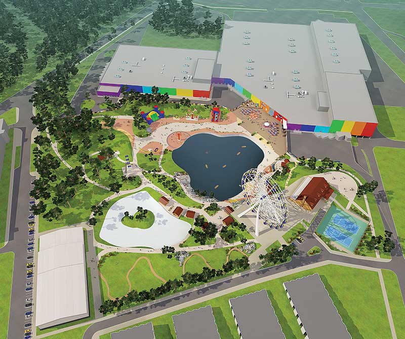
Large site area
Large site/plot plan (5 or 9 Buildings) for example, a Complex locality map with more detail, trees, and text; Or a large plot plan with 3-4 buildings + vicinity map, etc.
- 3D Aerial Renderings: $379 to $579 (*custom quotes for complex requirements)
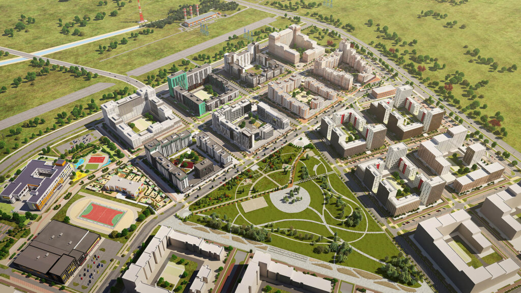
Extra large site area
(10+ Buildings) for example, Large scale/Complex map- high attention to detail, buildings, trees, footpaths, text, lots up to 250; it can be a Master plan, or, a town plan of a bigger area, etc.
- 3D Aerial Renderings: $479 to $779 (*custom quotes for complex requirements)
Why Choose Us for 3D Aerial Renderings?
- Price: Premium Quality Work at an Extremely Affordable Price
- Quality: Experienced & Highly-Talented 3D Designers at Work
- Time: Quick Turnaround at each Level; 24 Hours Delivery Available
- Deliverable “100% Satisfaction Guaranteed” to Clients
Our Clients Say It Best!
With HIGH QUALITY & CREATIVE 3D Aerial View Rendering Services, we have served 1,250+ Happy Clients & delivered them out-of-the-box modeling designs. Our Experienced and Highly Talented Designers are always committed to delivering PREMIUM QUALITY 3D Aerial Renders with dedicated UNLIMITED REVISIONS support.
How Are You So Affordable?
We are constantly asked, “Why are you so much cheaper than your competition?” It’s simple. Our experienced team, well-established customized processes, bulk amount orders, and operational setup in India allow us to keep our operating costs low, and we love to share these savings as an added advantage to our clients. This is where the saving for us is, and we pass that on to you!
Factors Deciding the Price / Cost of 3D Aerial Renderings
The pricing of 3D Aerial Renderings can be influenced by several factors:
- Complexity of the Project: The more intricate and detailed the project is, the more time and effort will be required to create an accurate 3D aerial rendering. Factors such as the architectural complexity, landscaping intricacy, and the presence of various elements (e.g., buildings, roads, vegetation) can impact the pricing.
- Level of Detail and Realism: Higher levels of detail and realism in the rendering, such as intricate textures, accurate lighting, and realistic materials, can increase the time and skill required for the rendering process. Achieving a high level of realism often demands more resources, thus affecting the pricing.
- Resolution and Output Quality: The final resolution and quality of the rendered image also play a role in pricing. Higher resolutions are necessary for larger prints or high-definition presentations, but they demand more computing power and time to render, which can contribute to higher costs.
- Project Timeline and Urgency: If there’s a tight deadline for the rendering, it may require additional resources to expedite the process. Rush orders or projects with short turnaround times could result in higher pricing due to the need to allocate more resources to meet the deadline.
- Software and Technology: The software and technology used to create 3D aerial renderings can impact pricing. Advanced software licenses and hardware requirements might contribute to higher costs, but they can also yield higher-quality results.
- Experience and Skill of the Renderer: Highly skilled 3D artists with a proven track record of creating realistic and visually appealing aerial renderings may command higher fees due to their expertise.
- Additional Services: If the rendering company offers additional services such as animations, virtual tours, or interactive presentations, these could be bundled into the pricing, affecting the overall cost.
- Project Scope and Size: The scale of the project area and the number of views or perspectives needed for the rendering can influence pricing. Larger projects or those requiring multiple views might have a higher cost.
- Client Requirements and Revisions: The number of revisions or changes requested by the client can impact pricing. Extensive revisions might require additional work and time, which can lead to higher costs.
- Market Demand and Competition: Pricing can also be influenced by market demand and competition among rendering companies. Rates may vary based on regional pricing trends and the competitive landscape.
Considering these factors when requesting 3D Aerial Renderings will help you understand the pricing structure and ensure you receive an accurate quote for your specific project.
Also, Read: 3D Exterior Rendering Cost
FAQs related to 3D Aerial Renderings
What are 3D aerial renderings?
3D aerial renderings are visual representations of architectural or landscaping projects created using computer software. They provide a realistic view of the project from an aerial perspective, helping stakeholders visualize the final outcome.
What is the purpose of 3D aerial renderings?
The main purpose of 3D aerial renderings is to help architects, urban planners, real estate developers, and other stakeholders understand how a project will look in its environment. They aid in making design decisions, obtaining project approvals, marketing projects, and presenting concepts to clients.
How are 3D aerial renderings created?
3D aerial renderings are created using specialized software that allows 3D artists to build and texture 3D models, set up lighting, and simulate environmental conditions. The software then generates a realistic image or video based on these parameters.
What information is needed to create a 3D aerial rendering?
To create a 3D aerial rendering, you’ll need architectural plans, site maps, landscape designs, material references, and any other relevant project details. The more information you provide, the more accurate the rendering will be.
How long does it take to create a 3D aerial rendering?
The time required depends on the complexity of the project, the level of detail, and the renderer’s workload. Simple renderings might take a few days, while more intricate ones could take several weeks.
What factors affect the cost of 3D aerial renderings?
The cost is influenced by factors such as project complexity, level of detail, resolution, urgency, and the renderer’s skill. Additional services like animations or virtual tours might also impact the cost.
What is the difference between 3D aerial renderings and 2D floor plans?
3D aerial renderings provide a realistic visual representation of the project from an elevated viewpoint, while 2D floor plans are simplified diagrams showing the layout of spaces from a top-down perspective.
Can I request revisions to the 3D aerial rendering?
Yes, most rendering companies allow for revisions to ensure the final product meets your expectations. However, excessive revisions might incur additional costs or affect the project timeline.
What industries benefit from 3D aerial renderings?
Industries like real estate, architecture, urban planning, landscaping, and property development benefit greatly from 3D aerial renderings to showcase designs and concepts.
Are 3D aerial renderings used only for still images?
No, 3D aerial renderings can also be used for animations, fly-through videos, and interactive presentations that allow viewers to explore the project from different angles. Also, Read: Real Estate 3D Property Renderings
Can 3D aerial renderings show landscaping and environmental elements?
Yes, 3D aerial renderings can incorporate landscaping, vegetation, water features, roads, and other environmental elements to create a holistic representation of the project’s surroundings.
How do I choose a reputable 3D rendering service?
Look for companies with a portfolio of high-quality work, positive client reviews, reasonable pricing, and clear communication. Requesting quotes and comparing services can help you make an informed choice.
Most popular software for 3D Aerial / Drone View Renderings
Several software options are widely used for creating 3D aerial drone renderings. Here are some of the most popular ones:
- SketchUp with Lumion or V-Ray: SketchUp is a user-friendly 3D modeling software often used by architects and designers. When combined with rendering plugins like Lumion or V-Ray, it allows for the creation of realistic 3D aerial renderings.
- Autodesk Revit with Autodesk 3ds Max: Revit is a Building Information Modeling (BIM) software commonly used in architecture and construction. It can be linked with Autodesk 3ds Max for advanced rendering and visualization, including aerial perspectives.
- Blender: Blender is a powerful open-source 3D creation suite that’s widely used for various purposes, including aerial renderings. It offers a comprehensive set of tools for modeling, texturing, lighting, and rendering.
- Cinema 4D: Cinema 4D is known for its user-friendly interface and is popular in the motion graphics and visualization industry. It can be used to create detailed 3D models and aerial renderings.
- Unity with ProBuilder and ProGrids: Unity is primarily a game development platform, but it’s increasingly used for architectural visualization and real-time 3D rendering. Tools like ProBuilder and ProGrids enhance its capabilities for creating architectural scenes.
- Enscape: Enscape is a real-time rendering and visualization plugin that integrates with popular design software like Revit, SketchUp, Rhino, and ArchiCAD. It allows for easy creation of immersive 3D aerial renderings.
- Lumion: Lumion is a standalone visualization software designed for creating stunning visualizations quickly and easily. It’s known for its user-friendly interface and real-time rendering capabilities.
- Terragen: Terragen specializes in natural landscapes and terrain generation. It’s often used to create highly realistic outdoor scenes and environments, making it suitable for aerial renderings with natural elements.
- Vue: Vue is another software popular for creating natural landscapes and environments. It’s used for adding realistic vegetation, atmospheric effects, and terrains to 3D scenes.
- RealityCapture: RealityCapture specializes in photogrammetry, which involves creating 3D models from photographs taken from drones. It’s particularly useful for capturing real-world environments and turning them into detailed 3D models.
Remember that the choice of software depends on your specific needs, your level of expertise, and the kind of aerial renderings you aim to create. It’s also worth considering compatibility with the software you use for 3D modeling and designing your projects.
Irresistible, Low-Cost Prices for 3D Aerial Renderings
Small site area
(1 or 2 Buildings) for example, a small area, a property map, a small shopping mall, etc.
- 3D Aerial Renderings: $149 to $249 (*custom quotes for complex requirements)
Medium site area
(3 or 4 Buildings) for example, a Regional map or small locality map, etc.
- 3D Aerial Renderings: $249 to $349 (*custom quotes for complex requirements)
Large site area
Large site/plot plan (5 or 9 Buildings) for example, a Complex locality map with more detail, trees, and text; Or a large plot plan with 3-4 buildings + vicinity map, etc.
- 3D Aerial Renderings: $379 to $579 (*custom quotes for complex requirements)
Extra large site area
(10+ Buildings) for example, Large scale/Complex map- high attention to detail, buildings, trees, footpaths, text, lots up to 250; it can be a Master plan, or, a town plan of a bigger area, etc.
- 3D Aerial Renderings: $479 to $779 (*custom quotes for complex requirements)
Submit Your Project Now:
Click here to Get Custom Quote
Contact
You can also submit your requirements here (use the below form):
[gravityform id=”2″ title=”false” description=”false”]