
Benefits and Advantages of 3D Site Plans: 3D site plans give you a better idea of what to expect from a building or a home. You can navigate around a house or a building and explore it much more easily. One of the best aspects of 3D plans is how they can help you save time and money. When you happen to be a developer and you have a 3D plan of the project, it means you will need a much shorter time to develop that property. This can mean you can develop quickly or have more opportunities. And that ultimately means you save money.
A 3D site plan is a great way to show a client your design before it’s built, or turn a client’s sketch into a realization. When a client sees a model of their home, they can make adjustments to it like landscaping or window placement before the building begins. It’s also a great way for an architect to make changes to the design before construction. Some architects will show clients a 3D site plan even before the client is building their property, to give them peace of mind that things will look like they imagined. It can be worth booking site visitations for architects before building because it will save the client time and money.
3D site plans enable a 2D drawing to look as though it is a 3D representation from multiple perspectives. They provide a real luxury of design space that can be seen from assorted perspectives. 3D site plans are the perfect way to present a robust, spatial vision to a client.
Table of Contents
Benefits and Advantages of 3D Site Plans
Comprehensive and Accurate site plans are also possible in 3D
3D site plans can be more accurate than 2D site plans or 2D floor plans, so the owner knows exactly how the site will look before construction begins. A 3D site plan rotates around, making it easier for the client to visualize what the site will actually look like. It can take 1 to 2 days to create a complete site plan, which is an advantage because site plans are easily changed to suit client specifications.
3D site plans offer a lot of advantages that traditional site plans don’t. They offer a detailed and comprehensive view of the site and the architectural elements and structure of whatever is being built. A 3D site plan can help you to avoid costly mistakes and unnecessary delays and to save time and money. The 3D site plans also offer a great opportunity to review and adjust the designs and layout of the construction site before the construction starts. There are a number of different advantages offered by 3D site plans. For example, they allow you to navigate the site and identify the best alignment and footprint for the construction of new buildings, which can save you a lot of time and money.
Also, Read: Site Plan vs Floor Plan – How these are fundamentally different?
It will allow you a clear visualization of the layout
3D site plans are a great way to visualize the space you have outside. It will allow you to see what your goals are and what is possible. 3D site plans also give you a clear visualization of the space available outside without the pressure of any constraints, which can lead to a lot of clarity. What a site plan does is take a digital drawing of a building on a flat plane and then extrude it along the x-y axis to represent the third dimension. It shows the perspective of the building in relation to the sun, the sky, the ground, and other buildings.
3D site plans were initially created for civil and infrastructure projects, but they’re now being used more and more for other things. You can get a 3D site plan of any property and neighborhood and then it’ll give you a clear and accurate visualization of the space for any size and location. You can resize it back and forth, or you can change the elevation in the design. This will help you in all your conceptualizing.
A 3D Site Plan is a must-have for any construction business looking to stand out from its competition. Producing a 3D Site Plan can help a company seek out contracts for a project they may not have been qualified for before. It also helps in the clear visualization of space. This is paramount for any construction business. A 3D Site Plan also saves time and money, as it means you don’t need to go through any trial and error setups.
It helps us plan the project scope and timelines
One of the big benefits of 3D site plans is that they can give you a well-rounded idea of what you’re planning to build. With scale models, your contractors can see exactly how everything will go together, or your clients can share their thoughts on what they’d like to see in the building you’re planning to construct. When you’re designing for a specific project, you need to consider all the angles, and 3D site plans will give you the most realistic idea of what the project will look like. You can really see how this will look by doing a 3D site plan and illustrative drawing showing illustrative elevations and sections. 3D site plans today are a very good way to show your project and the location.
It will represent the spatial dimensions
Producing accurate three-dimensional representations of a site is an important step in preparing for a construction project, and the benefits and advantages make it well worth the effort. The 3-dimensional view can help you better assess height, provide a more accurate proportion of the site area, and help you to create visualizations for what the project will look like. More accurate estimates can be developed for space for parking, walkways, and landscaping. It is also much easier to establish your property boundaries because much of the site can be seen at once.
Also, Read: How Site Plans are different from Floor Plans?
The 3D Site Plans can be used to visualize and share the spatial dimensions of a project. This helps the reader to comprehend the spatial dimensions and location of the project and activate knowledge and understanding of it. The 3D Site Plans can help architects and designers make better and more informed decisions and specifications about the project. The 3D Site Plans use interactive maps and environments to demonstrate and communicate spatial dimensions and detail of a project.
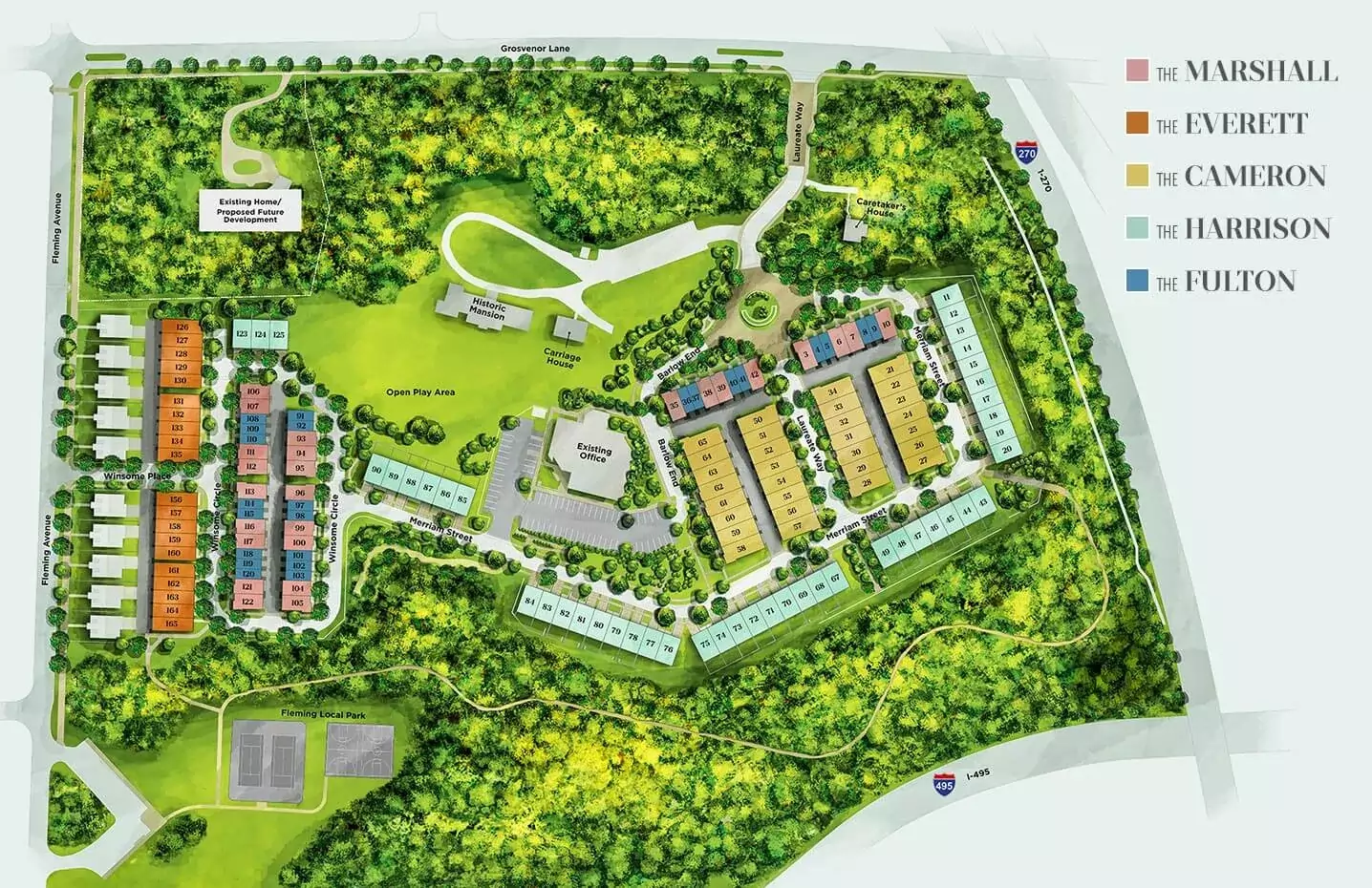
3D Site Plan Example Sample
Here we have shown a sample for the 3D site plan (exact upper view rendered).
Believe it or not, architects can now generate site plans in 3D. If you want to get a more realistic idea of how the project is going to look and feel, 3D plans are a great way to go.
Frequently Asked Questions (FAQs) with Answers
What is a 3D site plan?
A 3D site plan is a three-dimensional representation of a piece of land or property. This type of plan is typically used in the design and planning stages of a project, and can be used to visualize the layout of a space, the topography of a piece of land, or the location of features and buildings on a property.
How can a 3D site plan be used to improve project coordination and communication?
A three-dimensional site plan can help improve project coordination and communication by providing a more realistic and comprehensive view of the project site. This can help all involved parties better understand the layout of the project site and potential obstacles or challenges that may need to be considered or addressed. In addition, a 3D site plan can help to more clearly illustrate the proposed project timeline and milestones, which can aid in the coordination of efforts and resources.
What are the benefits of using a 3D site plan compared to a 2D site plan?
A three-dimensional (3D) site plan provides many benefits over a two-dimensional (2D) site plan. These benefits include:
- Increased accuracy: A 3D site plan is a more accurate representation of a property than a 2D site plan. This is because a 3D site plan includes all three dimensions (length, width, and height), whereas a 2D site plan only includes two of these dimensions (length and width).
- Increased clarity: A 3D site plan is generally more clear and easier to understand than a 2D site plan. This is because a 3D site plan provides a more realistic view of a property, which can help to identify potential problems or areas of concern.
What are the benefits of using a 3D site plan?
3D site plans offer a number of advantages over traditional 2D site plans. They provide a more realistic and accurate representation of the site, making it easier to visualize and understand the layout. They can also be used to create animated walk-throughs or fly-overs, giving potential buyers or renters a better sense of the property. And because they are digital files, they can be easily shared and edited, making the planning process more efficient.
How can a 3D site plan help you visualize your project?
A 3D site plan can help you visualize your project by allowing you to see a three-dimensional representation of the project site. This can be helpful in understanding the layout of the project and in seeing how the various components of the project fit together.
What are some things to consider when creating a 3D site plan?
Some things to consider when creating a 3D site plan include:
- The size of the site
- The topography of the site
- The climate of the site
- The vegetation of the site
- The wildlife of the site
- The infrastructure of the site
What software is typically used to create a 3D site plan?
There is no single answer to this question as there are a variety of software programs that can be used to create a 3D site plan. Some of the most popular software programs used for this purpose include Google SketchUp, Autodesk 3ds Max, and Blender.
How long does it usually take to create a 3D site plan?
It usually takes about 1-2 weeks to create a 3D site plan. This time frame can vary depending on the size and complexity of the project.
What kind of information do you need to create a 3D site plan?
In order to create a 3D site plan, you will need detailed information about the property, including the dimensions of the land, the location of buildings and other structures, and any features of the land that will be relevant to the plan. You will also need to create a model of the terrain, which can be generated using data from a topographical map.
Service Page: 2D 3D Site Plan Services